


Geo Area - GPS Area Calculator
Deskripsi Geo Area - GPS Area Calculator
GEO AREA measurement app is a free area and perimeter measurement app also referred to as GPS area calculator for land measurement, planimeter to measure area on map, or platometer and is used to measure field areas, collect ground samples, GIS surveys - all shareable on various GIS platforms.
WHAT MAKES GEO AREA UNIQUE?
- Highly accurate area measurement and land surveyor app, verified and tested with ground data
- GIS mapping app with multiple area and perimeter units
- Ability to generate KML files
- Sharing KML for visualization on any GIS
- Ability to edit, delete records
- User friendly
- Tap the map to mark area, OR
- Use the phone GPS receiver
- Ability to pause, start and stop GPS mode so that you can easily select the desired points
- Unlike our competitor Apps, Geo Area has NO RESTRICTIONS ON SHARING your data
- Not just an area calculator, its much more
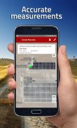
AREA MEASUREMENT ACCURACY TEST EXAMPLE:
One of the screenshots shows Google Tennis Courts at (1600 Amphitheatre Pkwy,Mountain View) - check this yourself to see how accurately Geo Area works:
Tennis court dimensions are: 36 ft(10.97m) x 78 ft(23.78m)
Therefore, Area= 36 ft(10.97m) x 78 ft(23.78m)=2808 square feet(260.8666 square metres)
Perimeter = Sum of all four sides=228 ft (69.5m)
You can change units from the application settings from feet to meters OR to acres OR to hectares OR to kanals OR to kilometers. Your choice!
GEO AREA MEASUREMENT APP LETS YOU DO THE FOLLOWING:
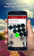
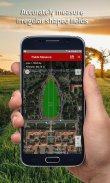
1. Measure the land area and perimeter of just about anything on the ground as seen on Google Maps
2. Use area measurement and perimeter units of your choice including feet, meter, hectare, Kanal (area units for India), kilometer, yards, and acre.
3. Either tap on the points of interest on the Google Maps to mark area, OR
4. Use the phone's GPS to mark the field boundary
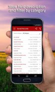
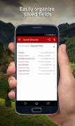
5. Create Categories of your choice where you can group fields,please refer to the screenshots
6. Create unlimited categories
7. Share and see the marked fields on any GIS for instance the Google Earth
GEO AREA MEASUREMENT APP is for:
1. Mapping and Land surveys
2. Farmers, for farm management
3. Land area measurement
4. Construction surveys
5. Agronomists
6. Town planners
7. Construction surveyor
8. GIS data collection
9. GPS fields area measure
10. Farm fencing
11. Sports track measurement
12. Construction sites and building sites area
13. Asset mapping
14. Landscape artists
Geo Area Measurement app is used by farmers for: crop yield estimation, crop area measurement, and agriculture land and area mesaurement. Geo Area has been used in conjunction with remote sensing (satellite imagery e.g. SPOT 6, SPOT 7) and GIS applications, to collect ground truth data, field records, and farm data. Geo Area measurement app is ideal for land cover analysis, vegetation mapping and remote sensing where Regions of interests (ROIs) or the Points of Interest (POIs) or Area of Interest (AOI) collected through Geo Area measurement app. As seen in the example, Geo Area is ideal for area measurement (area calculator) and perimeter of sports grounds, cricket grounds, football pitches, tennis courts, badminton courts, parking lot area, residential space, running track and rental space. Other applications of Geo area measurement app include Patwari or Patvari and the old tape-measure system for land record management.
Geo Area measurement app is also used for crop yield estimation for cotton, wheat, rice, sugarcane, maize, tobacco, Virginia, FCV tobacco, vegetables, banana plantations, dates, orchards mapping, forest mapping and GPS based area measurement of deforestation area. Geo Area measurement is also used to estimate fertilizers required for agricultural lands based on the calculated area. It is a free and simple planimeter to measure distance and land area on a map.
Nothing is complete in itself - we are learning from YOU to make Geo Area measurement app more useful. Thank you for your comments and feedback.
GEO pengukuran AREA aplikasi adalah daerah bebas dan perimeter aplikasi pengukuran juga disebut sebagai GPS wilayah kalkulator untuk pengukuran tanah, planimeter untuk mengukur area pada peta, atau platometer dan digunakan untuk mengukur daerah lapangan, mengumpulkan sampel tanah, survei GIS - semua dapat dibagikan pada berbagai platform GIS.
APA YANG MEMBUAT GEO AREA UNIK?
- Pengukuran luas sangat akurat dan surveyor tanah aplikasi, diverifikasi dan diuji dengan data tanah
- Pemetaan GIS aplikasi dengan beberapa daerah dan perimeter unit
- Kemampuan untuk menghasilkan file KML
- Berbagi KML untuk visualisasi GIS setiap
- Kemampuan untuk mengedit, menghapus catatan
- Mudah digunakan
- Tekan peta untuk menandai daerah, OR
- Gunakan penerima telepon GPS
- Kemampuan untuk jeda, memulai dan menghentikan modus GPS sehingga Anda dapat dengan mudah memilih poin yang diinginkan
- Tidak seperti Apps pesaing kami, Geo Lokasi memiliki NO PEMBATASAN BERBAGI data Anda
- Tidak hanya kalkulator daerah, yang jauh lebih
AREA PENGUKURAN AKURASI TES CONTOH:
Salah satu screenshot menunjukkan lapangan tenis Google di (1600 Amphitheatre Parkway, Mountain View) - periksa ini sendiri untuk melihat seberapa akurat Geo Lokasi bekerja:
dimensi lapangan tenis: 36 ft (10.97m) x 78 ft (23.78m)
Oleh karena itu, di Area = 36 ft (10.97m) x 78 ft (23.78m) = 2808 kaki persegi (260,8666 meter persegi)
Perimeter = Jumlah seluruh empat sisi = 228 ft (69.5m)
Anda dapat mengubah unit dari pengaturan aplikasi dari kaki ke meter OR untuk acres ATAU untuk hektar ATAU untuk kanals ATAU ke kilometer. Pilihanmu!
GEO AREA PENGUKURAN APP LETS ANDA BERIKUT:
1. Ukur luas lahan dan perimeter apa saja di tanah seperti yang terlihat di Google Maps
2. Gunakan daerah pengukuran dan perimeter unit pilihan Anda termasuk kaki, meter, hektar, Kanal (unit daerah untuk India), kilometer, pekarangan, dan acre.
3. Entah tekan pada tempat menarik di Google Maps untuk menandai daerah, OR
4. Gunakan GPS telepon untuk menandai batas lapangan
5. Buat Kategori pilihan Anda di mana Anda dapat bidang kelompok, silakan lihat screenshot
6. Buat kategori terbatas
7. Berbagi dan melihat bidang yang ditandai pada setiap GIS misalnya Google Earth
GEO AREA PENGUKURAN APP adalah untuk:
1. survei Pemetaan dan Tanah
2. Petani, untuk manajemen pertanian
3. Pengukuran Tanah daerah
4. survei Konstruksi
5. Ahli agronomi
6. perencana Kota
7. surveyor Konstruksi
pengumpulan data 8. GIS
9. GPS ladang ukuran daerah
10. Pertanian pagar
11. Olahraga pengukuran lintasan
situs dan situs bangunan 12. Konstruksi daerah
pemetaan 13. Aset
seniman 14. Landscape
Geo Lokasi Pengukuran aplikasi yang digunakan oleh petani untuk: hasil estimasi tanaman, pengukuran area tanaman, dan tanah pertanian dan daerah mesaurement. Geo Lokasi telah digunakan dalam hubungannya dengan penginderaan jauh (citra satelit misalnya SPOT 6, SPOT 7) dan aplikasi GIS, untuk mengumpulkan data dasar kebenaran, catatan lapangan, dan data pertanian. Geo Lokasi pengukuran aplikasi sangat ideal untuk analisis tutupan lahan, pemetaan vegetasi dan penginderaan jauh di mana Daerah kepentingan (ROI) atau Tempat Menarik (POI) atau Area of Interest (AOI) yang dikumpulkan melalui Geo Lokasi pengukuran aplikasi. Seperti yang terlihat pada contoh, Geo Lokasi sangat ideal untuk pengukuran daerah (area kalkulator) dan keliling lapangan olahraga, alasan kriket, lapangan sepak bola, lapangan tenis, lapangan bulu tangkis, daerah parkir, ruang hunian, jalur lari dan ruang sewa. Aplikasi lain dari Geo pengukuran daerah aplikasi termasuk Patwari atau Patvari dan tua sistem pita-ukuran untuk pengelolaan record tanah.
Geo Lokasi pengukuran aplikasi juga digunakan untuk estimasi hasil panen kapas, gandum, beras, tebu, jagung, tembakau, Virginia, tembakau FCV, sayuran, perkebunan pisang, tanggal, pemetaan kebun, pemetaan hutan dan GPS pengukuran daerah berdasarkan wilayah deforestasi. pengukuran Geo Lokasi juga digunakan untuk memperkirakan pupuk diperlukan untuk lahan pertanian berdasarkan daerah dihitung. Ini adalah planimeter gratis dan sederhana untuk mengukur jarak dan luas lahan pada peta.
Tidak ada yang lengkap dalam dirinya sendiri - kita belajar dari ANDA untuk membuat Geo Lokasi pengukuran aplikasi yang lebih berguna. Terima kasih atas komentar dan umpan balik.
GEO AREA measurement app is a free area and perimeter measurement app also referred to as GPS area calculator for land measurement, planimeter to measure area on map, or platometer and is used to measure field areas, collect ground samples, GIS surveys - all shareable on various GIS platforms.
WHAT MAKES GEO AREA UNIQUE?
- Highly accurate area measurement and land surveyor app, verified and tested with ground data
- GIS mapping app with multiple area and perimeter units
- Ability to generate KML files
- Sharing KML for visualization on any GIS
- Ability to edit, delete records
- User friendly
- Tap the map to mark area, OR
- Use the phone GPS receiver
- Ability to pause, start and stop GPS mode so that you can easily select the desired points
- Unlike our competitor Apps, Geo Area has NO RESTRICTIONS ON SHARING your data
- Not just an area calculator, its much more
AREA MEASUREMENT ACCURACY TEST EXAMPLE:
One of the screenshots shows Google Tennis Courts at (1600 Amphitheatre Pkwy,Mountain View) - check this yourself to see how accurately Geo Area works:
Tennis court dimensions are: 36 ft(10.97m) x 78 ft(23.78m)
Therefore, Area= 36 ft(10.97m) x 78 ft(23.78m)=2808 square feet(260.8666 square metres)
Perimeter = Sum of all four sides=228 ft (69.5m)
You can change units from the application settings from feet to meters OR to acres OR to hectares OR to kanals OR to kilometers. Your choice!
GEO AREA MEASUREMENT APP LETS YOU DO THE FOLLOWING:
1. Measure the land area and perimeter of just about anything on the ground as seen on Google Maps
2. Use area measurement and perimeter units of your choice including feet, meter, hectare, Kanal (area units for India), kilometer, yards, and acre.
3. Either tap on the points of interest on the Google Maps to mark area, OR
4. Use the phone's GPS to mark the field boundary
5. Create Categories of your choice where you can group fields,please refer to the screenshots
6. Create unlimited categories
7. Share and see the marked fields on any GIS for instance the Google Earth
GEO AREA MEASUREMENT APP is for:
1. Mapping and Land surveys
2. Farmers, for farm management
3. Land area measurement
4. Construction surveys
5. Agronomists
6. Town planners
7. Construction surveyor
8. GIS data collection
9. GPS fields area measure
10. Farm fencing
11. Sports track measurement
12. Construction sites and building sites area
13. Asset mapping
14. Landscape artists
Geo Area Measurement app is used by farmers for: crop yield estimation, crop area measurement, and agriculture land and area mesaurement. Geo Area has been used in conjunction with remote sensing (satellite imagery e.g. SPOT 6, SPOT 7) and GIS applications, to collect ground truth data, field records, and farm data. Geo Area measurement app is ideal for land cover analysis, vegetation mapping and remote sensing where Regions of interests (ROIs) or the Points of Interest (POIs) or Area of Interest (AOI) collected through Geo Area measurement app. As seen in the example, Geo Area is ideal for area measurement (area calculator) and perimeter of sports grounds, cricket grounds, football pitches, tennis courts, badminton courts, parking lot area, residential space, running track and rental space. Other applications of Geo area measurement app include Patwari or Patvari and the old tape-measure system for land record management.
Geo Area measurement app is also used for crop yield estimation for cotton, wheat, rice, sugarcane, maize, tobacco, Virginia, FCV tobacco, vegetables, banana plantations, dates, orchards mapping, forest mapping and GPS based area measurement of deforestation area. Geo Area measurement is also used to estimate fertilizers required for agricultural lands based on the calculated area. It is a free and simple planimeter to measure distance and land area on a map.
Nothing is complete in itself - we are learning from YOU to make Geo Area measurement app more useful. Thank you for your comments and feedback.
Geo Area - GPS Area Calculator - Versi 1.6
(04-11-2016)Geo Area - GPS Area Calculator - Informasi APK
Versi APK: 1.6Paket: com.cegmas.geoareaVersi Terakhir dari Geo Area - GPS Area Calculator
Versi lain


Aplikasi pada kategori yang sama

Anda juga mungkin suka...


